
A Novel Approach to Map Permeability Using Passive Seismic Emission Tomography
The utility of passive seismic emission tomography for mapping geothermal permeability has been tested at two locations in northern Nevada, San Emidio and Crescent Valley. The San Emidio study area overlaps a geothermal field in production since 1987 and also a new, hotter resource recently drilled to the south of the production field. In contrast, the subsurface at the Crescent Valley study area is poorly constrained by drilling with geothermal potential mainly indicated by geothermometry of hot spring discharges, shallow, high heat flow, and reports of blown out mineral exploration wells.
Newly acquired magnetotelluric data and passive seismic data collected with tightly spaced geophone arrays are combined with historic drilling, active seismic, and potential fields data to generate 3-D permeability maps. A cooperative inversion methodology has been developed using active seismic, magnetotelluric, and gravity data in order to produce more robust velocity models for passive seismic data processing without requiring expensive 3-D active seismic surveys. The cooperative inversion estimates velocities from other geophysical data where no prior seismic velocity information is available.
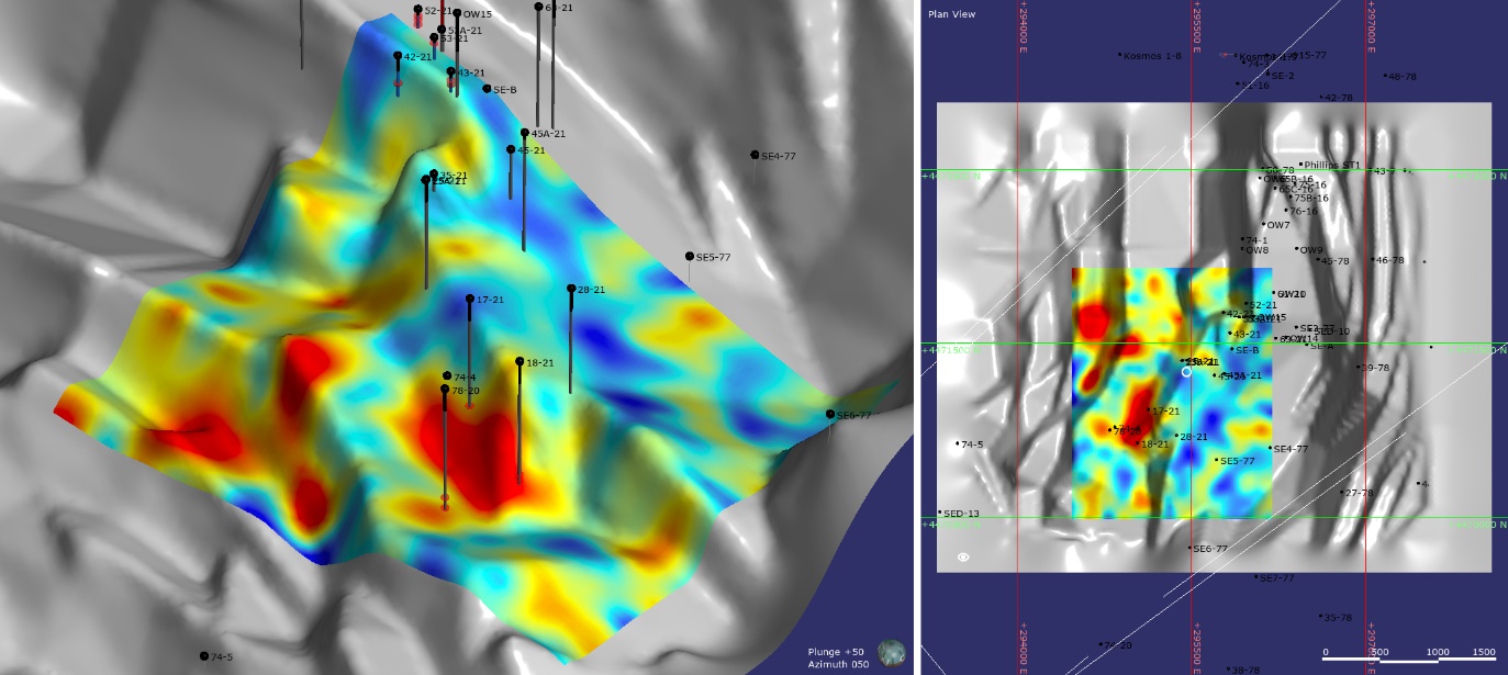
At San Emidio, permeability associated with the known geothermal reservoir coincides with acoustic energy anomalies defined by passive seismic emission tomography and with low resistivity anomalies defined by magnetotelluric data while the structural setting of these anomalies is constrained by drilling, gravity, and other geophysics, and refined with cooperative inversion results. At Crescent Valley, acoustic energy anomalies defined by passive seismic emission tomography and low resistivity anomalies defined by magnetotelluric data occur down-dip from and basin-ward of hot springs discharging along the main range-front fault. These anomalies are located where range-front-parallel faulting potentially intersects faulting associated with a NNW-trending horst that is defined by geophysics and drilling, including historic mineral well blow outs. With limited subsurface data, cooperative inversion maximizes the utility of magnetotelluric data at Crescent Valley by using them to estimate seismic velocities that refine processing of passive seismic data and to refine resistivity patterns to better define structures controlling geothermal permeability.
A robust 3-D permeability map can be created using magnetotelluric and dense passive seismic datasets when they are combined with drilling and potential fields datasets that help constrain the structural and geological controls on geothermal permeability. Cooperative inversion of seismic and magnetotelluric datasets provides more robust and location-specific velocity models that optimize processing and interpretation of passive seismic data while also increasing the utility of magnetotelluric data for identifying structures that control geothermal permeability.
Using the methodologies developed herein, proposed drill targets have been selected at San Emidio and Crescent Valley for testing during Phase 2.